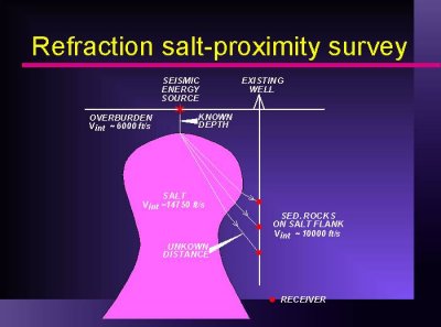
Refraction seismic survey recorded in a wellbore on the flank of a salt dome.
A seismic source is positioned above the shallowes portion of the salt.
Total travel times along the refracted raypath are recorded by
3-component geophones in the wellbore off the flank of the dome.
The depth to the top salt has to be known
(a disposable well has to be drilled at the source location).
From the top-salt depth, and the interval velocities of the salt,
the overburden and the sediment on the flank,
a salt profile can be computed. The resulting salt image is represented
as a series of points in XYZ space (salt-exit points)
positioned relative to the wellbore, in which the survey was acquired.
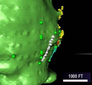
Results of several salt-proximity surveys (colored octagons) were used together with
with well picks (yellow spheres) to build a 3D grid of the salt-sediment interface.
Discovering the overhanging salt shown on this visualization was responsible
for assing 20% reserves to this aging onshore Louisiana field.
